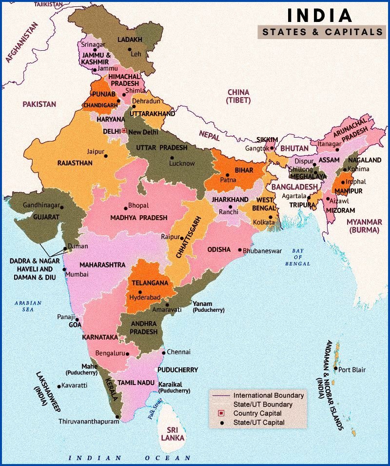
India is a vast country located in South Asia and has a rich and diverse cultural heritage. The shape of India’s landmass is often compared to a diamond, and its boundaries are marked by the Himalayan mountain range to the north and the Indian Ocean to the south. The country shares land borders with Pakistan to the west, China, Nepal, and Bhutan to the north, and Myanmar and Bangladesh to the east.
The map of India showcases its various states, Union territories, and major cities, highlighting the country’s unique geographical features such as its long coastline, the Western Ghats, the Eastern Ghats, and the Deccan Plateau. The country’s capital city, New Delhi, is located in the northern region of the country, while other major cities such as Mumbai, Bangalore, Chennai, Hyderabad, Kolkata, and Ahmedabad are spread out across the country.
The India map also displays important rivers such as the Ganges, Brahmaputra, Godavari, Krishna, and Cauvery that originate in the Himalayas and traverse the country’s fertile plains before flowing into the Bay of Bengal and Arabian Sea. India is also known for its rich biodiversity, and its map features numerous wildlife sanctuaries, national parks, and forest reserves that are home to a wide variety of flora and fauna.
Overall, the India map is a representation of the country’s diversity, beauty, and rich cultural heritage, showcasing the various regions, landmarks, and natural features that make it a unique and fascinating place.

How many states in India?
India is comprised of 28 states and 8 Union territories. The 28 states are – Andhra Pradesh, Arunachal Pradesh, Assam, Bihar, Chhattisgarh, Goa, Gujarat, Haryana, Himachal Pradesh, Jharkhand, Karnataka, Kerala, Madhya Pradesh, Maharashtra, Manipur, Meghalaya, Mizoram, Nagaland, Odisha, Punjab, Rajasthan, Sikkim, Tamil Nadu, Telangana, Tripura, Uttar Pradesh, Uttarakhand, and West Bengal.
The 8 Union territories are – Andaman and Nicobar Islands, Chandigarh, Dadra and Nagar Haveli and Daman and Diu, Lakshadweep, Delhi, Puducherry, Jammu and Kashmir, and Ladakh.
⇒ Resume CV Templates – Free Download Now